Alpine CrownThe great climbs of the Alps All climbs

Col du Petit Saint-Bernard

2188 m · Italy

Also: Bernard · Col du Petit · Colle del Piccolo San Bernardo · Kleiner Sankt Bernhard · Saint

Tour de France4×Giro d'Italia1×1949–2009

Col du Petit Saint-Bernard is a 2188 m road climb in Italy with 2 sides. From Séez: 23.9 km at an average of 5.4%, climbing 1292 m; the steepest 500 m is about 11.5%. From La Thuile: 22.6 km at an average of 5.2%, climbing 1167 m; the steepest 500 m is about 8.6%.

Open
Usually open late May–October; closed in winter
Road
D1090 (RD 1090) from Séez via La Rosière to the col

The 2 sides

From La Thuile

From La ThuileSéez2188 m
Start: Pré-Saint-Didier · 1025 m
22.6kmto the top
5.2%average grade
+1167 m climbingmax ≈8.6%Hors catégorie
1250150017502000≈8.6%14.8 km≈8.3%17.5 km≈7.8%18.6 km051015205.14.84.73.74.25.15.76.25.06.75.43.0km%/km
1250150017502000≈8.6%14.8 km≈8.3%17.5 km051015205.13.13.72.95.77.16.76.5km%/km
Bends
≈36 hairpins
Faces
northeast
Lights
Front and rear. 6 tunnels, longest 600 m.
Every km of the La Thuile side
KmFromToGrade
0–11025 m1076 m5.1%
1–21076 m1128 m5.2%
2–31128 m1176 m4.8%
3–41176 m1207 m3.1%
4–51207 m1255 m4.7%
5–61255 m1294 m4.0%
6–71294 m1332 m3.7%
7–81332 m1391 m5.9%
8–91391 m1433 m4.2%
9–101433 m1461 m2.9%
10–111461 m1512 m5.1%
11–121512 m1568 m5.6%
12–131568 m1625 m5.7%
13–141625 m1690 m6.5%
14–151690 m1752 m6.2%
15–161752 m1823 m7.1%
16–171823 m1874 m5.0%
17–181874 m1940 m6.6%
18–191940 m2007 m6.7%
19–202007 m2058 m5.1%
20–212058 m2111 m5.4%
21–222111 m2176 m6.5%
22–22.62176 m2193 m3.0%

From Séez

From La ThuileSéez2188 m
Start: Séez · 896 m
23.9kmto the top
5.4%average grade
+1292 m climbingmax ≈11.5%Hors catégorie
100015002000≈11.0%6.4 km≈10.7%10.4 km≈11.5%11.4 km051015204.35.33.09.38.08.74.14.84.24.44.75.1km%/km
100015002000≈11.0%6.4 km≈11.5%11.4 km051015204.35.29.36.64.14.84.45.3km%/km
Bends
≈20 hairpins
Faces
southwest
Every km of the Séez side
KmFromToGrade
0–1896 m939 m4.3%
1–2939 m999 m5.9%
2–3999 m1052 m5.3%
3–41052 m1104 m5.2%
4–51104 m1134 m3.0%
5–61134 m1159 m2.5%
6–71159 m1252 m9.3%
7–81252 m1344 m9.2%
8–91344 m1424 m8.0%
9–101424 m1491 m6.6%
10–111491 m1578 m8.7%
11–121578 m1659 m8.2%
12–131659 m1700 m4.1%
13–141700 m1744 m4.3%
14–151744 m1792 m4.8%
15–161792 m1840 m4.8%
16–171840 m1882 m4.2%
17–181882 m1925 m4.3%
18–191925 m1968 m4.4%
19–201968 m2008 m4.0%
20–212008 m2054 m4.7%
21–222054 m2107 m5.3%
22–232107 m2158 m5.1%
23–23.92158 m2188 m3.5%
0–4%4–7%7–10%10–12%12%+

The number under each km is its average grade. Flags mark the steepest stretches of about 500 m; the steepest is the max on the sign. Heights come from an elevation model, so grades are approximate.

Open on the map→Navigate ↗
Col du Petit Saint-Bernard
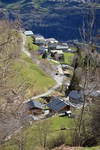
Photo: DimiTalen · CC0 · Wikimedia Commons

The climb

The Col du Petit Saint-Bernard sits at 2188 m on the France-Italy border, linking the Tarentaise valley in Savoie with the Aosta valley via Pré-Saint-Didier.

The canonical climb runs up the French side on the D1090 from Séez, just above Bourg-Saint-Maurice, passing the ski resort of La Rosière at around the 22 km mark. It is long but rarely steep: roughly 27.5 km gaining about 1289 m at a 4.69% average, with the gradient seldom exceeding 8% and the steeper pitches saved for the final kilometres above La Rosière.

The road is open seasonally, typically May to October, and the summit holds a Roman column with a statue of Saint Bernard and the old hospice.

Source: Wikipedia

Race history

Tour de France4×
Giro d'Italia1×

5 passages, 1949 to 2009

Up: from La ThuileDown: from Séez

Grand Tours only
Every passage
  1. 1949 · Tour de France · from Séez
  2. 1959 · Tour de France · from Séez
  3. 1959 · Giro d'Italia · from Séez
  4. 1963 · Tour de France · from Séez
  5. 2009 · Tour de France · from La Thuile

Nearby climbs

Col du Petit Saint-Bernard2188 m