A dead-end climb up the Val de Bagnes above Le Châble and Fionnay to the Barrage de Mauvoisin — a great arch dam at the head of the valley, near 1,960 m.
The road threads tunnels and gorge switchbacks to the dam wall beneath the Grand Combin.
1963 m · Switzerland
Also: Mauvoisin · Lac de Mauvoisin · Val de Bagnes
Barrage de Mauvoisin is a 1963 m road climb in Switzerland. From Sembrancher: 24 km at an average of 5.2%, climbing 1250 m; the steepest 500 m is about 12.2%.
| Km | From | To | Grade |
|---|---|---|---|
| 0–1 | 708 m | 753 m | 4.5% |
| 1–2 | 753 m | 793 m | 4.0% |
| 2–3 | 793 m | 832 m | 3.9% |
| 3–4 | 832 m | 806 m | -2.6% |
| 4–5 | 806 m | 812 m | 0.6% |
| 5–6 | 812 m | 835 m | 2.3% |
| 6–7 | 835 m | 844 m | 0.9% |
| 7–8 | 844 m | 892 m | 4.8% |
| 8–9 | 892 m | 902 m | 1.0% |
| 9–10 | 902 m | 963 m | 6.1% |
| 10–11 | 963 m | 1059 m | 9.6% |
| 11–12 | 1059 m | 1118 m | 5.9% |
| 12–13 | 1118 m | 1207 m | 8.9% |
| 13–14 | 1207 m | 1305 m | 9.8% |
| 14–15 | 1305 m | 1348 m | 4.3% |
| 15–16 | 1348 m | 1413 m | 6.5% |
| 16–17 | 1413 m | 1487 m | 7.4% |
| 17–18 | 1487 m | 1545 m | 5.8% |
| 18–19 | 1545 m | 1571 m | 2.6% |
| 19–20 | 1571 m | 1605 m | 3.4% |
| 20–21 | 1605 m | 1682 m | 7.7% |
| 21–22 | 1682 m | 1759 m | 7.7% |
| 22–23 | 1759 m | 1845 m | 8.5% |
| 23–24.0 | 1845 m | 1958 m | 11.4% |
The number under each km is its average grade. Flags mark the steepest stretches of about 500 m; the steepest is the max on the sign. Heights come from an elevation model, so grades are approximate.
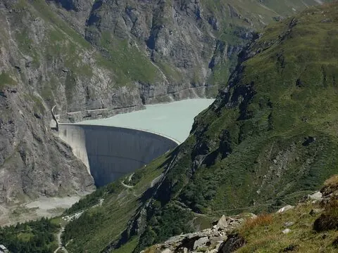
A dead-end climb up the Val de Bagnes above Le Châble and Fionnay to the Barrage de Mauvoisin — a great arch dam at the head of the valley, near 1,960 m.
The road threads tunnels and gorge switchbacks to the dam wall beneath the Grand Combin.